方案摘要
方案下载| 应用领域 | 地矿 |
| 检测样本 | 其他 |
| 检测项目 | |
| 参考标准 | 暂无 |
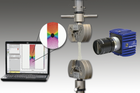
非介入式全场应变形变测量,可用于各种材料压缩和拉伸形变试验中,也可用于冶金,地质,矿产研究和工业领域。
The collapse of Mount St. Helens (United States) on 18 May 1980 is one of the only incidents
of its kind that was visually witnessed and instrumentally recorded. Previous analyses
determined that the northern fl ank of the mountain failed, which resulted in a rockslide, and
disintegrated during its mobilization to form a blocky facies and hummocky terrain in the
downslope region. Gary Rosenquist’s iconic photographs of the initial 18 May collapse were
here analyzed by using a modern photogrammetric method to track portions of the moving
fl ank across the photographs in the sequence. Thirty years after the 1980 Mount St. Helens
rockslide, the digital image correlation technique enabled a precise investigation of the associated
displacement vectors and strain. A listric basal detachment and several associated faults
at the lateral edge of the rockslide were identifi ed. In addition, the heterogeneous movements
and a number of shear zones were detected within the sliding block, which had previously
been assumed to be cohesive. The results of my study demonstrate the value of using optical
images for strain analyses of active volcanoes—even decades after recording.
文献贡献者


在一个双稳湍流涡旋火焰中,对间歇性动态的时间-频率定位
Particle-laden Taylor-Couette流:高阶转变和径向局部波浪涡旋的证据

7根杆束的流体-结构相互作用:用实验数据对比数值模拟
相关产品
汽车光学检测系统AIS
PT403型波长可调谐皮秒激光器
ANL系列高能量高重复频率DPSS纳秒激光器
APL4206 系列高能量皮秒激光放大器
UltraFlux FF/FT 5000 高能量可调谐飞秒激光器系统
UltraFlux FT300型波长可调谐飞秒激光器系统
Ekspla 超高功率激光器系统SYLOS 2A
LaVision PTUx 可编程时间控制单元
LaVision 用于粒子成像测速PIV的相机
LaVision StrainMaser 全场应变测试系统组件
LaVision 用于数字图像相关DIC的相机
LaVision StrainMaster 数字图像相关分析软件包
LaVision 标定板
LaVision StrainMaster 形变应变成像测量系统
LaVision StrainMaster DVC 体视全场应变测量系统

关注

拨打电话

留言咨询